 Say what? Have I lost my mind?
Oh yes. And long ago. But that’s not important right now.
Instead, consider this: today’s blog post is being sponsored by the Greek Letter ‘Omega!’
So what could this greek letter possibly be doing in a blog on Northwest Weather? As I’ve said on KOIN Local 6 the last few nights, it’s the easiest way to explain why we’re “shutting off the tap” in our northwest skies for an extended stretch of dry weather…right as we get into the heart of the rainy season.
What Oregon & Washington Should See This Time Of Year
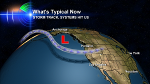
 Â We should see something like this image where the Jet Stream, or storm track, aims frequently at Seattle, Vancouver and Portland. Kind of like it did last week when we ask if the rain is ever going to end. And 3-5 days a week are wet. But this scenario is on hold for now.
 We should see something like this image where the Jet Stream, or storm track, aims frequently at Seattle, Vancouver and Portland. Kind of like it did last week when we ask if the rain is ever going to end. And 3-5 days a week are wet. But this scenario is on hold for now.
Omega Block Developing In Atmosphere – Northwest Suddenly Goes Dry
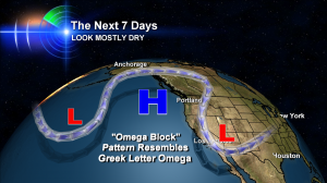
  Ah, here it is–the Omega Block as we call it in meteorology. It’s an odd looking and difficult to form pattern where the storm track creates the Greek letter Omega or something fairly close to it. Can you see the resemblance?
For starters, this pattern blocks our storms and sends most of them up and over us, taking them to places mainly east of Oregon & Washington. But it’s called a “Block” because it’s a pattern that tends to stick in the atmosphere once it forms. This means if it gives you dry weather–like it does in this case for Portland and Vancover and Beaverton–it will keep giving you dry weather.
And where storms are forming in other places ‘downwind’ from Oregon and Washington, those spots will likely see unusually stormy weather or more frequent storms — again and again — until this pattern shifts!
Forecasting Tools Keep Portland Dry For A Looooong Time
It’s going to be very interesting to see how long we can stay dry with this set up. Our forecasting tools have a range of possibilities going right now–some keep us almost totally dry all the way until mid-December! Personally, I have a hard time believing that’s true. But we’ll see.
And just a reminder, La Nina is more closely linked with December to February weather — so I’m sure we’ll get plenty of storm and mountain snow action. But for now, it’s on hold…

Bruce; You got me fascinated! The barometric pressure here at 6pm was 30.77 inches. I’ve seen it only higher than this once before on Dec.14, 1996. Oddly back then skies were cloudy and we actually had a light shower near that time (9:30am) and day. I hope we’ll break the record today!
Wow, Roland–that’s super cool. Let me know what happens!
Hi Bruce: we reached a peak pressure of 30.82 inches last night around 9pm. That is the highest I’ve ever seen it! Now it’s down slightly this morning. I have to make a slight correction over what I said yesterday; We did have a 30.78 inch reading on Dec.14th, 1996, but it repeated itself a couple of days later. By then skies cleared.