 For awhile, La Nina seemed to be on vacation.
Much of January was dry, snow-pack was shrinking and you needed sunglasses more than a winter coat.
That was then and this is now.
La Nina To The Northwest: I’m Still Running The Show
Let’s compare what La Nina should mean for our winter weather vs. what’s happening this week:
- Big mountain snow. Check. We’re looking at 3-4 feet of new snow at the higher resorts this week. A possible record breaking week!
- Unusually low snow levels. Check. Even the Coast Range will see up to a foot of snow this week. At times, the snow level may drop to 1000′ and possibly as low as 500′.
- Unusually stormy weather. Check. We’ll see a couple rounds of gusty winds and plenty of sideways rain to go with it.
- Unusually cool temperatures. Check. It’s not the arctic air of last week. But it’s quite a stretch of temperatures in the 40s when we should be in the 50s.
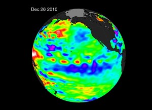
La Nina is defined by unusually cool waters in the Pacific Ocean that alter the storm track and change what we expect, especially in winter. In the image above La Nina is all that blue down near the equator.
The climate pattern is starting to weaken but still forecast to last into Spring, impacting our weather along the way. Tilting things in favor of a cooler, wetter spring than we’d typically see in the Pacific Northwest.
G-r-e-a-t.

Leave a Reply