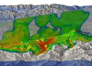
If this new 3-D image of the Mount St. Helens eruption ever finds its way onto a postcard, it may be the next best seller!
Because more than thirty years after Mount St. Helens shook and exploded, the top selling postcards in Portland, Oregon and Vancouver, Washington
continue to be of this incredible mountain and its 1980 blast.
New 3-D Image Of Eruption Offers New Insights Into St. Helens Blast
The eruption on the morning of May 18, 1980 caused devestation that most geologists never thought possible in such a single, short lived event.Â
But once it did happen, the research began into how it occurred and how it could’ve buried so many areas north of the blast zone.
Was it some sort of ‘jet’ or focused explosion that increased the blasts power to the north?
Geologists ran re-creations on super computers as best they could over the years, in 2-d, and none of them adequately ‘modeled’ or re-created the blast the way it was known to have actually happened. Until now.
Researchers Amanda Clarke of Arizona State University and Tomaso Esposti Ongaro, a vulcanologist at Italy’s Istituto Nazionale di Geofisica e Vulcanologia (please, don’t ask me to translate!) created this image. It’s believed to be the most accurate recreation of how the blast truly happened and the first time this has ever been done in three dimensions.
Gravity Apparently Increased Damage On Mount St. Helen’s North Side
If you look at the reds and yellows in this image, you’re looking at the greatest intensity of the eruption and blast. Almost all of these things are downhill from the volcano’s summit. And most are in low points along the terrain. The researchers determined gravity played a bigger role than anyone anticipated in pulling everything downhill, creating faster ash and gas blasts than the volcano could do on its own and because of that, the damage and devastation was worse.
The Point Of St. Helens 3-D Research Is To The Make World Safer
The successful simulation is part of an effort to make things safer for those near volcanoes in the future. Researcher Ongaro says, “We can use this to explore eruption scenarios for other volcanoes. While we can’t predict exactly what will happen, it could prove extremely useful.â€
Not just at Mount St. Helens but at volcanoes around the world where these kinds of simulations are someday created.
Perhaps geologists could plug in certain readings–and then predict what the outcome will likely be and who to evacuate–before the volcanoes erupt. Volcanoes are creatures of habit, so to speak, so if you can model what it did once, it will likely help you in the future.
Here’s an incredible gallery of Mount St. Helens Images. Thirty one of them, in fact, for the 31st anniversary of the blast!


Leave a Reply