I mean it’s Valentine’s Day. So thought I’d better have a poem somewhere in here!
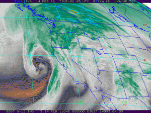
But kidding aside, this headline is also true. Two different storm systems off the west coast (you see the southern one in this image, all curled up!) will make Monday very interesting.
- The ‘blowing sand’ part because the Oregon Coast will likely see wind gusts of 70-80mph today, which is why there’s a High Wind Warning until this evening.
- The I-5 corridor could see gusts of 35-45mph at times today–I guess that’s ‘blowing moss’? Should’ve worked into headline!
- The ‘blowing snow’ part because of gusty winds and dumping snow tonight in the Oregon Cascades. The forecast simulations I looked at just now give Government Camp and places higher in elevation 10-15″ of snow by 10am Tuesday morning. With more after that.
 This looks like it will be the biggest snow storm since the end of December with some areas getting two feet of snow. It could be the highest totals are in Central Oregon, at Mt. Bachelor. We’ll see if the forecast tools are correct on that one or not.
Cooler Air Seems On Track, Snow Levels Set To Drop
It’s by no means an arctic blast. However, cooler air does move in by Tuesday bringing snow to the Cascade Foothills and possibly the passes of Highway 26 & 6 in the Coast Range. By Thursday morning, I think the snow level is down to 1,000′ or a bit less. But it’s the usual NW trick: will we still have enough moisture to get some snowflakes to these low levels or will we just turn dry and cold?Â
I’m watching this closely to see what develops!


Leave a Reply