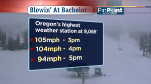
 And the worst news for skiers and boarders: these triple digit wind gusts would’ve been either a cross-wind or a head-wind.
So if you didn’t get blown sideways you might’ve just hung on the downhill without, um, going downhill!
The incredible wind gusts you see in this graphic peaked at 105.2mph at 3pm on Monday February 7, 2011. The information is from the highest weather station in the state of Oregon at the summit of Mt. Bachelor.
A lot of people think the highest weather reporting station in Oregon is up on Mt. Hood above Timberline Lodgeat elevation 7,000 feet. But Mt. Bachelor Ski Resort in central Oregon has four weather stations higher up than Timberline’s.
Three Interesting Things About 100mph Gusts In The Oregon Cascades
- As the winds increased, temperatures dropped. So colder air was racing into the skies above us and that process created strong wind.
- Generally speaking, winds increase quickly with height. So it’s not too surprising our strongest winds this winter happened on Mt. Hood in December and this time on Mt. Bachelor.
- One of the reasons winds travel so quickly high up is the lack of things to run into. Air moving at 500 feet hits buildings, hills, trees, the KOIN tower, etc. Air at 9.000 feet only finds a mountain or two!
Along with these winds came fresh snow. Mt. Hood Meadows, Timberline Lodge, Mt. Hood Ski Bowl and Mt. Bachelor rang up totals of 5-10″ which is not only great news for skiers and boarders (now that the wind is gone!) but this should help put the breaks on the shrinking snow-pack in the Pacific Northwest.
Because even though another dry stretch is about to start the cold air up above us will keep the fresh snow where it is.

Leave a Reply