It’s a battle of rural versus urban.
Country life versus city living.
And man versus nature.
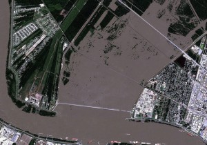
You’re looking at an incredible (and brand new) satellite view of the NOCO Levee near New Orleans, Louisiana. A company named Digital Globe takes images like these.
In this particular picture of Louisiana flooding from space, here’s what we’re looking at: the Mississippi River runs at the bottom and left. Urban areas would probably be underwater now…if nothing had been done. But instead, you can see the flooded farm fields that run straight up the center of this photo. Many of gates on this NOCO Levee are open, creating a relief valve for the Mississippi River allowing it’s water to flood farm fields instead of waiting for that to happen in the city.
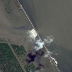
Morganza Levee Flooding Underway, Image From Space
Another incredible image, in a series from Digital Globeshows the Morganza Levee. If you click on this image to make it bigger, you’ll clearly see the ‘white water’ created by the Mississippi River taking advantage of gates opened on this levee, flooding more rural and agricultural areas.  The swollen Mississippi River is on the right in this particular photo, the Morganza Levee slices across at an angle and the water is flowing to the left through the opened gates.
Cause Of 2011 Mississippi River Flooding – How Did We Get Here?
On my bio page, Glenn posted this question: “Is the Mississippi River flooding from the rain storms from a couple months ago? Or is it some fast snow melt from up North?”
Great question, Glenn. Because the answer is, both. The Mississippi River map is incredible: it starts at Lake, Itasca, Minnesota. It travels more than 2,200 miles. The river itself and the streams and rivers that feed into it pull in water from 31 states! Isn’t that crazy? I guess they don’t call it the ‘might Mississippi’ for nothin’!
This year, an unusually large snow melt across Canada, northern tier U.S. states and the mid-west had levels rising. Then parts of the mid-west and southeastern U.S. had 20″ of rain in as little as one week’s time. The end result is a seemingly endless flood as the ‘crest’ or biggest ‘swell’ of these flood waters make their way through the system until the water can reach the Gulf of Mexico.
This is sure to be another in a string of multi-billion dollar disasters for the U.S. But more than that, it’s another one that touches the lives of millions of people who have in some way felt the impact of the 2011 flood.
Â


Leave a Reply