With previous ‘promises’ of snow in mind I’ve really been “kicking the tires” of this week’s forecast.
Â
When it comes to possible record breaking cold and accumulating snow to sea level it looks like the forecast is pretty solid at this point.
Â
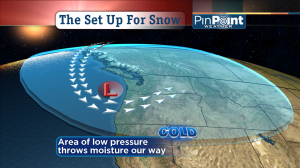
This image shows the basic setup: unusually cold air invading from our northwest and an area of Low pressure (the ‘L’) that drags that cold air over water, adds moisture, then spins that moist air into our skies.
Â
Five Important Things You Should Know:
Â
- Tuesday: You’re fine traveling in the I-5 corridor, even though you cold see snow flakes mix in. Places like the wet hills could see a temporary dusting. Highs are in the 40s and rain showers and sun breaks are in the forecast. But, there could be 4″ of snow today on Coast Range passes (Hwy 6 & Hwy 26) and 6-12″ falling on Cascades passes. Snow advisories are in effect for both mountain ranges.
- Tuesday evening: hilly parts of the Portland-Vancouver metro area and north will see snow showers, with some accumulation possible. The valley floor could see snow showers but accumulation looks doubtful.
- Wednesday & Thursday: Both morning commutes will likely involve areas of accumulating snow and/or slick conditions. We’re on track for widespread snow showers that pass through, along with some sun breaks. Any break in the showers could lift the snow level above the valley floor for a bit, especially Wednesday. And Wednesday’s morning commute should be easier, overall. But I believe almost all of us (down to sea level) will see snow these days. And many of us on the valley floor, will see at least temporary accumulations–especially Wednesday night & Thursday.
- How much snow you get depends on the showers that hit your area. The forecast simulations are showing ‘bands’ of showers. Almost like lines drawn on a map. The longer you’re under one of these bands the faster the snow piles up. If you get a sun break afterward–and it’s afternoon–the snow will start melting. Bands could easily drop a couple of inches on an area before moving on. I hope some of the big ones hit our house.
- The COLD: this is more than just another little dip into cool weather. Lows by the end of the week should be in the 18-22 degree range. Record breaking. So think of that when it comes to protecting the plants, the pipes, the pets and the kids! Oh. And yourself, too!
Â
Are we having fun yet? If this isn’t enough, then stay tuned. The long range forecast tools are calling for another possible round of cold and low snow for Oregon and Washington the same time next week.
 So much for Punxsutawney Phil predicting an early spring…


Leave a Reply