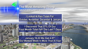
 While digging through the record books, I discovered something quite crazy about the rain over the last 7 days in Portland.
27% of the rainy season’s total (this starts with our water year on October 1 each year) fell during the last 7 days. Isn’t that a crazy statistic?
It’s certainly rare.
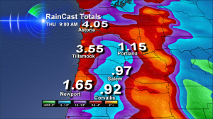
Now another atmospheric river (like a pipeline of water in the sky) is setting up again to slam the northwest starting today. Here’s how much rain our KOIN Local6 RainCast says is possible:
 If these totals are right, then we’ll have to watch the coast range, the coastal hills of southwest Washington–and the Centralia area, in particular. But the Oregon and Washington Cascades areas in general are also potential trouble spots because of all the snow melt.
The actual rain totals will depend on where the heavy rain bulls-eye sets up and how long it stays in one area. If it keeps moving around, maybe we escape without major trouble. But last week, that bulls-eye did not budge from Turner, Corvallis & Salem and we saw what a problem that was.
So, now through Thursday afternoon we’re under a flood watch — which means just that — we need to watch our rain totals and rivers.
Lots of rain for you there! I’ve collected less than 2 inches here (Vancouver BC) over the last 4 days. We also didn’t get the heavy snows, so there’s no flood dangers (thank goodness). I hope you get through the next few days safely!
Roland–you guys know how to live up there! We’ll see how February turns out. There are always a few surprises…at least a few…
Thanks, Bruce! I certainly am looking forward to February’s surprises.