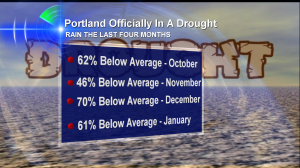
 It’s been an incredible four months around the northwest.
During that time, Portland has missed out on about 10″ of rain it should have gotten to make it an average year. The city has had 7.82″ of rain since October 1st when on average it would have seen 17.41″.
I’ve honestly lost count of the number of days that I’ve needed sunglasses instead rain gear–that’s the kind of fall and winter it has been.
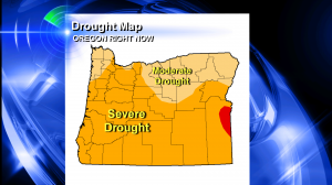
A lack of rain and gray in the Willamette Valley also spells trouble for the Oregon Cascades snowpack. It is running just 10-35% of average at this point in January 2014. No wonder most of the state, including Portland, is in what the U.S. Drought Monitor calls a “severe drought.”
 Here is Oregon’s drought map. Right now, when it comes to rain, we’re giving the rainy season of 2000-2001 a run for the money. That was the year that ‘water wars’ broke out in southern Oregon. Farmers vs. fish. And it was not pretty.
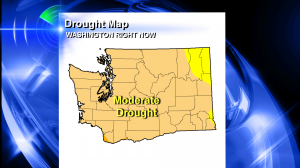
 Here is Washington’s drought map. The state has had more rain than most of Oregon and significantly more in the way of mountain snow: snowpack is 30-60% of average as of mid-January 2014.
It’s hard to say what the long term impacts will be as we get into spring and summer of 2014. Many times I’ve seen us turn very wet in spring after a dry winter and that can help bail us out, at least to some degree. Will it happen this time? We’ll see.
But over the next two weeks at least–it appears Portland will have 1/2″ of rain or less. That continues our trend of being way below average when it comes to rain.

Hi Bruce; The situation here north of the 49th parallel isn’t much different. I’ve calculated for October to December that we’ve had about 47% of our normal precipitation total. We’ve done better in January, (near average so far), but only because the 6 day stretch from January 7-12th. If things keep on going, we’ll still end up below average for January as well.