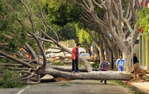
 On the night the Oregon Duck’s clinched their spot to go back to the Rose Bowl in Pasadena…people in that very city were in the middle of what you see in this picture: cleaning up from a damaging Santa Ana wind storm that came in two different blasts.
This picture is a Pasadena city street. So many trees were blown down by gusts up to 80mph that some residents were basically trapped because both sides of their street were covered by trees and there was no way to drive out of there!
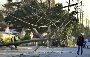
At the peak of this southern California wind storm, more than 300,000 people were without power.   Fire crews responded to hundreds of power lines down on roads. It was unlike anything in recent memory for many folks in southern California.
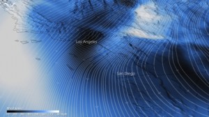
 Â This NOAA Image uses a cool 3-D view to tell the story. The winds are coming toward you in this image (the arrows attached to some of the lines confirm the direction) and the closer the lines are together, the more intense the wind. These lines are closest together over the mountains–and coming down the foothills into places like Pasadena, California.
 This NOAA Image uses a cool 3-D view to tell the story. The winds are coming toward you in this image (the arrows attached to some of the lines confirm the direction) and the closer the lines are together, the more intense the wind. These lines are closest together over the mountains–and coming down the foothills into places like Pasadena, California.
The National Weather Service says the peak gusts topped 140mph on some mountain ridges up above the LA Basin–that’s equivalent to the wind speeds you’d see in a major hurricane!
Portland And Seattle Weather Linked To What Caused The Southern California “Santa Ana’ Wind Storm
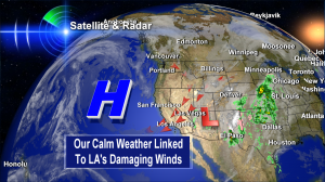
  Wind is caused by pressure differences between different places. This image shows the record setting high pressure area over the Pacific–as you probably know, it’s the ‘H’. On December 1st, 2011, Portland, Oregon set a new record for the highest pressure ever recorded during the month of December. (30.75″) The same day, Seattle recorded its highest barometric pressure (30.81″) for any month at Sea-Tac Airport since records started there in 1948.
That high pressure helped work with a strong area of low pressure (the ‘L’) over the desert southwest to create what you might call in simple terms a funneling effect that took your typical Santa Ana winds and super charged them. That’s over simplifying just a bit, but it’s the gist of what caused this California wind storm that downed trees and knocked out power.
 Â Want to see more? Check out the LA Times Photo Gallery where I found these damage photos.
 Want to see more? Check out the LA Times Photo Gallery where I found these damage photos.

This California wind storm got me thinking about summer west winds in the Columbia River Gorge. We rarely see gusts much above 50mph here. I’m wondering how wild things might get if an equally lucky, and equally flukish, setup occurred for the Gorge…
Karl–good point. In our case…it would have to be an east wind event because of extreme high pressure (and cold) east of the Cascades. Last winter some in eastern Clark County had gusts top 50mph as this cold air spilled down the Cascades into SW Washington. One of these days it may happen–and be more widespread. We’ll see.
Thanks for your post!
I’m glad to see your report! This seemed poorly reported nationally – it seems few across the country knew that according to PG&E and Edison that about four million households were without power. Some even reported it as ‘Santa Anas wind’ which this most certainly wasn’t!
Our house in Santa Cruz sustained bombardment from wind and trees for about thirty-two hours. I don’t think I can recall a storm so long in my life nor worse – the worst prior was the Columbus Day storm in S Oregon when I was a kid, and although it had hundred mile an hour winds, it was over much quicker.
This wind event was spread over four very large states and was just wind, not a region’s effect like the Santa Anas or most of the Columbia Gorge winds. Santa Cruz is three hundred miles from Pasadena, that’s a really wide swath to cut.
Our power was out for four days, and nearly every other house in our neighborhood has a branch through a window or roof. Pretty rough stuff!