Will it snow this second week of November 2014 in the Portland-Vancouver metro area?
I’m already getting that question on Facebook!
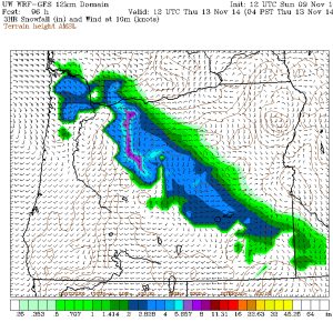
This image from a forecast model (the Sunday 12z GFS) shows where it will allegedly be snowing this Thursday at 4a.m.Â
It paints snow right over the Portland-Vancouver metro area and well into the Gorge! (Not much south of PDX, though…)
The real question is…should we believe this…at all?
For more on what I think about all this–I’ve copied over my forecast that I just posted on the Bruce Sussman Weather App.
By the way, do you have my weather app yet? Here’s where to get it:
iPhone and iPad: Bruce Sussman Weather AppÂ
Android: Bruce Sussman Weather App
And now, the forecast. This will be a fun week to keep an eye on the weather!
Tuesday & Wednesday: Sunny, dry, gusty east wind. Scattered power outages are likely near the Gorge where winds could top 40mph. Morning lows in the 20s and highs in the low 40s or so for the Portland-Vancouver metro area. Much less wind the closer you get to Salem so afternoons may hit the mid-upper 40s there.
Watch this one closely: early Thursday morning, before the morning commute really gets going, forecast models are bringing in some moisture from the southwest. As this moves into our really cold air things could get interesting.
In fact, one of the model runs on Sunday claimed we will see snow around parts of the Portland-Vancouver metro area very early Thursday morning, before sunrise. Will it happen?
You’re kidding right? You don’t expect me to answer that do you…it’s way too risky!
Well, alright, here are my latest thoughts and they are subject to change: if the forecast tools are right about the cold air and the gusty east wind as this Thursday morning system rolls in, there is at least a ‘possibility’ of some sort of wintry mix from say Troutdale and across the metro area out to Forest Grove (watching for the Forest Grove Effect…will snow pile up here?) and the west slopes of the Coast Range. Perhaps snow or  freezing rain changing to snow? Or maybe just a shot of freezing rain. Any of these could happen are possible.
But before you get your hopes (or fears?) up, be advised: the forecast tools may be overdoing how cold it will actually get west of the mountains.
I have seen many times where they do this several days ahead of time and then the really cold air just never makes it as far west as we are. Often, we don’t know about this until the last minute.
Please know I’m watching this closely—and I’ll continue giving you the daily play by play right here on my app!
By the way, whatever happens should not be long lived except in the Gorge, where temperatures will really struggle to climb on Thursday.I expect snow in the Gorge.


Hello Bruce: The cold dry air is definetly coming in here now (7am, Nov.11): Reports of power outages in the Fraser Valley from the winds, relative humidity really dropped from 84% late last evening to 44% this morning. Temperatures ironically rose from 34F near midnight to 39F around 3:30 am here, but this coming night we’ll really see freezing temperatures once the winds drop off. Snow in Vancouver, B.C? Probably not- we don’t have the geographic set-up that Portland does, but you never know…