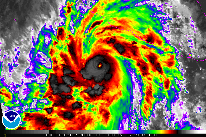
 The news seemed to catch everyone I talked to off guard: with steady winds topping 200mph–Patricia became the strongest hurricane, ever recorded, in the western hemisphere.
The western hemisphere includes the Atlantic, the Caribbean, the Gulf of Mexico and ‘half’ of the Pacific that is closest to our continent.
For perspective, this storm is more powerful than Hurricane Katrina. That’s right, more powerful.
In fact, the World Meteorological Organization says the storm’s intensity is comparable to Typhoon Haiyan which killed more than 6,000 people in the Phillipines when it made landfall in 2013. One of the biggest killers was ‘storm surge’. This is how much the storm actually raises sea level–with crashing waves still happening on top of that.
So what can we expect when Hurricane Patricia hits Mexico besides flooding?
Exact storm track will determine where the worst damage is. As I write this, the eye is expected to go between Puerto Vallarta and Manzanillo, Mexico. But here are some things we can expect, even if the location is uncertain just yet:
- Â Watch where Hurricane Patricia’s eye make landfall. To the right (either south or east of the eye in this case) of landfall is where the most massive storm surge will be. This is because the wind blowing one direction for so many areas is literally ‘piling up’ the ocean in this spot. When the storm makes landfall, this massively high pile of water gets pushed onshore. I won’t be surprised if we’re talking sea level rise of 20 feet or more–so at least the height of a two story building. That kind of water claims lives and destroys buildings.
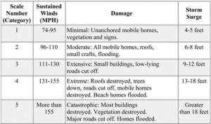
- The strongest winds in every hurricane are near the eye wall. (Pretty amazing there is no wind inside the eye itself, isn’t it?)  The locations hit most directly by the area just outside the eye will see the strongest winds. Damage near this part of the storm will be catastrophic, with most buildings simply destroyed. The greater the distance you are from the eye when the storm passes overhead, the lower the wind speeds will be. Look at this chart for how damage and storm surge varies with windspeed:
- The damage from a Category 5 hurricane is approximately 500 times greater than the damage from a category 1!
- The only known hurricane to make landfall near Puerto Vallarta that was almost this strength was in 1959.
I am really heartbroken for the people in Mexico and worried as well for the tourists who may be trying to ride this one out. In the days to come we are going to see some really tragic things from this region with a significant road to recovery. If you’re a praying person, please join me in saying one today for those who are about to go through this.
One final note: the Atlantic has been pretty quiet this year when it comes to hurricanes, while the Pacific has been very busy with typhoons and hurricanes. That is very typical of El Nino. And this year is one of the strongest El Ninos ever recorded.

I pray that these people are wrapped in the loving arms of our Father and the destruction and loss of life is minimal. Amen.
If you could rent a car go south as it’s going NE. We saw so many people leaving when Andrew came through. The thing was not enough people left the area. They were homeless for the longest time…
Wow What A Hurricane Patricia Have Become And My The Man Above Keep An Eye On All. Good Day To All Weather Buffs Out Tnere.