 By now we’ve all seen the devastation on the ground and by helicopter. And if you’re reading from the Southeast, maybe you’ve seen it in person.
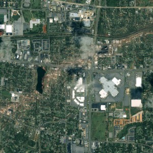
But this image is the Tuscaloosa tornado track from outer space. A company named GeoEye took this image on April 28, 2011 – the day after the tornado outbreak.
The diagonal brown line (like part of the image has been erased) is where the tornado was on the ground in Tuscaloosa, Alabama.
This image was captured by the IKONOS Satellite while it was 423 miles above earth and moving at 17,000 miles per hour.
You can click on the image to expand it. But for the full resolution quality you can download for free, go to GeoEye’s web site.
Images like this can really help in clean up efforts. And they can help National Weather Service investigators as they piece together all that took place in this rare event to improve warnings in the future.

[…] Here is the tornado damage in Tuscaloosa from outer space. […]