 Here it comes: many of us are about to see our first snow of the season!
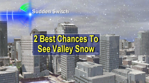
In fact, it looks like we have not one, but two really good chances to see snow in the next week.
Saturday Forecast – Both Rainy & Snowy For Many Of Us
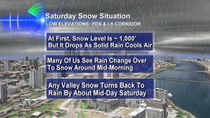
 This graphic from my Friday evening newscasts explains what the game plan is for snow. At least in my head, anyway. We’ll see what happens. But I do expect a lot of us to see snowflakes.
- Any of us could see barkdust temporarily turn white
- Sticking snow is most likely in Western Washington County and the typical areas of Clark County where snow tends to add up (you know if you live there!)
- Sticking snow, for a bit, is also likely in many of the hilly areas around the I-5 Corridor (West Hills, Cooper Mountain, Mt. Scott, etc.)
- I expect roads on the valley floor to stay wet and temperatures should remain above freezing for most of us during this taste of winter
- Once the heavy precipitation ends, the snow level ‘pops’ to about 1,500′ or maybe a little higher – so the Coast Range passes will probably only be snowy in the morning. But above 1,200′ there could be 2″+
- The Cascades will see 4-12″ of snow by Sunday morning, and by Monday morning that total may hit the 2-3′ range for higher ski resorts. This is big!
- After Saturday, our next chance to see snow appears to be Tuesday Morning, with cold air back in place and scattered showers around. Stay tuned!
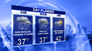
 This is my updated day planner. Some places will be colder than 37 at times–PDX may even dip below that temporarily. But the message here is that the snow is just a memory by mid-afternoon and we’re in the low 40s!
Possible Strong Winds Sunday Night Into Monday
Another thing our forecasting tools have been warning about the last few days…is a strong storm center on Sunday night and Monday moving in across either Puget Sound or southern B.C. This will likely mean very strong winds at the coast (at least 70+ but probably stronger) and could possibly mean 35-50mph gusts in the Willamette Valley and Southwest Washington. The time to watch is later Sunday into Monday. We’ll get a lot of valley rain then, too. The exact storm track will make a big difference. So, stay tuned.
I hope you are able to enjoy the changing weather in Oregon and Washington with those you care about in the coming week!

Hi Bruce: It’s turned to snow here(Vancouver BC) for the past hour, with a few spots starting to whiten. However, I don’t expect it to last, as temperatures are above freezing, and will stay that way. Any place outside the city above 1000 feet however, could see accumulations!