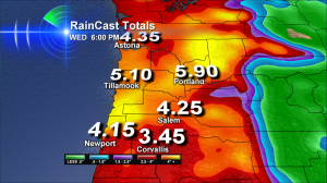
 You’re looking at our KOIN Local 6 computer created estimates of the total rainfall between now and Wednesday evening.
C-R-A-Z-Y.
But true?
Can we believe Portland could see almost 6″ of rain this week or that Tillamook could see 5″ of rain?
I’m treating this like I treat any estimate of rain totals: don’t count on hitting an exact number that’s bound to change as we go through the next few days. But do take away the message the number is trying to convey. Let’s say Portland only gets half this estimated rain, that’s still 3″ and a heck of a message for us! Here are the rest of the messages this week:
- Parts of Western Oregon and Southwest Washington will have their wettest week of the year (for all of 2011) – likely Portland-Vancouver
- A few parts of the Northwest could have their highest rain totals in several years – could be Portland-Vancouver, less likely Salem & south
- More significant snow may fall at the start of this event – mainly Cascades
- Major low level snow melt below 5,000′ (starting either Monday night or Tuesday morning) will greatly increase flood danger in small and medium sized rivers that drain both the Cascades and the Coast Range
Here’s what decides how this is going down: Certain parts of the storm are more ‘energized’ than others. If Portland spends too much time under this part of the storm, I could see how we could possibly reach a 6″ total.
But usually, the most intense rain is where winds above us interact with one of our mountain ranges–and that’s the real bulls-eye of heaviest rain. So how long a storm stays stalled over us–and where the bulls-eye sets up will really determine who will be hardest hit. Right now our computer thinks Portland is on the list–but that can easily shift to another location. So we all need to be watching the forecast closely this week.
These La Nina Powered Storms: Wind Makers, Too
Storm number one hits Monday morning–it’s the weaker of the two main systems we’re dealing with.  Peak gusts are likely 60mph at the coast and 35mph for the I-5 Corridor. It could mean a few scattered power outages.
Storm number two hits later Monday night into Tuesday. It could create 80mph gusts in coastal towns with gusts of 90+ along beaches and headlands. Inland, this is the kind of storm that always worries me. Just about 2,000′ above sea level we’ll have gusty winds of 70mph+ with this storm.
Right now it looks like those strong winds stay above the surface. But if things are oriented just a little differently–then some of these strong winds can work their way down to the surface in a sudden and very damaging fashion. Especially after another drenching round of rain where trees are basically anchored in mud.
Many times I’ve seen wind situations like this come and go without reaching their full potential inland. Let’s hope this is one of those times! We’ll know more Monday night as this storm starts closing in.
The most significant rain from this event seems to start later Monday night and last into sometime Wednesday.
I’m surprised about how many people already have their Christmas lights up – and I wish I was one of those people. Because it’s going to be a very wet task if I want those lights shining by Thanksgiving!

Oh my! I need to find a boat! Thanks for the info Bruce!
we’re going to need a bigger boat.
KOIN needs a Like button!
Cynthia–no doubt!
So glad we live on a boat, at least we can ride this storm out.
We will rock and roll a little more than normal!