 If a trees fall during the morning commute, will people in their cars hear it?
We may find out Tuesday morning if our KOIN Local 6 forecasting tools are correct.
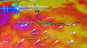
Everything I look at keeps pointing to Willamette Valley wind ramping up overnight – with peak winds sometime between 5-10am Tuesday morning.
This graphic shows the sustained winds expected–and I think gusts will likely be 40-50mph. Enough to bring down at least some trees and push some of us into the ‘no power’ zone. There’s still a chance winds could be stronger–as I mentioned last night. But this is a very complicated scenario and right now this is as good as I can nail down!
Also of note: the models try and increase wind again Tuesday night. That may or may not happen but I’m watching it.
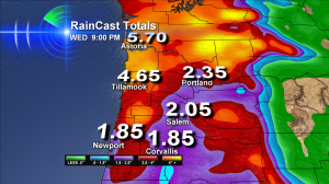
Biggest Flood Threat Appears To Be North & West Of Portland
 Â This graphic looks a lot ‘safer’ for the valley than the one in last night’s post. Basically, all our forecast tools took the heaviest rain and moved it to the North Coast Range of Oregon, plus the Coastal Hills of Washington and the Washington Cascades. So if this remains the case, it will mean less flood trouble in the Portland-Vancouver-Salem and Central Oregon Coast areas.
 This graphic looks a lot ‘safer’ for the valley than the one in last night’s post. Basically, all our forecast tools took the heaviest rain and moved it to the North Coast Range of Oregon, plus the Coastal Hills of Washington and the Washington Cascades. So if this remains the case, it will mean less flood trouble in the Portland-Vancouver-Salem and Central Oregon Coast areas.
I still expect short term urban flood issues when rain is heavy for too long. We’ll likely see a collection of flooded street corners, backed up storm drains and the usual stuff like that.
And when you put wind and rain in the mix–a lot of other ‘unexpected’ events are likely. A slide? A sinkhole? An urban stream that floods a local business or park? All of these remain possible.
Stay dry — stay safe — and have a great Tuesday!

My wife and I have an argment that you might be able to solve.
I say that in the 7-day forecast, the low temperature at the bottom of the day is for the lows the night of that day. My wife says the low temperature at the bottom of the day is for the Morning of that day .
Which one is it? I would appreciate the answer via e-mail. Thanks Much.
Ron–this is a great question that many people have asked about. It’s probably a blog post waiting to happen!
Because our coldest time of day is in the morning (most of the time) — the answer — is that those are the lows I expect that morning, followed by the high temperature above expected later that day.
This works well about 95% of the time. The other 5% it’s a real mess because we might hit our high at midnight or some totally random time like 7am — then see falling temperatures all day, etc. Then I have to do some extra explaining for sure!
Thanks for asking–and for reading and watching. I hope you guys have a great night!