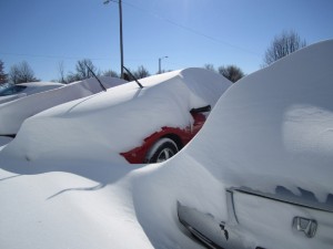
 The February 2011 blizzard closed twenty-five interstates.Â
It impacted about 100 million people.
And it was Chicago’s third biggest blizzard on record. More than 20″ of snow fell there.
Even places with less snow had big drifts. My cousin Shelley took this picture of the storm aftermath in Topeka, Kansas the day after the storm. So we all get the picture that many people will now spend days digging out.
But here in the Pacific Northwest we’re on the downside of another unusually sunny and dry stretch. And that’s shrinking our Northwest Snow-pack in a hurry.
I put in a call to my friend Jon Lea (the snow survey guy) over at the NRCS office in Portland. And these are the facts he gave me on Washington and Oregon snow-pack:
- Oregon and Washington snow-pack peaked this season on December 30, 2010.
Oregon’s Peak was 134% of average
Washington’s Peak was 105% of average - Now, here’s where we stand.
Oregon snow-pack is 79% of average
Washington snow-pack is 80% of average
Now, there’s still lots of time to make up some lost ground if we get big February & March storms. And I bet we’ll get them. Rarely do we get an unusually dry stretch of weather during the rainy season without paying for it all spring! Right? Right.

Leave a Reply