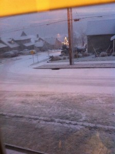
 Temperatures are falling, the east wind is howling and a storm system lurks off the coast of Oregon and Washington as we roll into Christmas Eve.
Could a sled, landing on your rooftop, be next?
Well, don’t hold your breath on that one…but do keep an eye out the window all the way through Christmas Eve night for the possibility of either light snow or freezing rain, caused by the system moving inland.
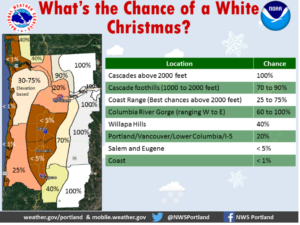
For the record, the long-term “chance of a white Christmas in Portland” is bad – it’s just 1%. Right now the National Weather Service in Portland is putting the odds at about 20% for Christmas 2017. And the odds are much higher, elsewhere.

Christmas Eve Forecast Possibilities – a ‘World of a Difference’
Here’s something that cracks me up.
Suddenly it is the USA vs. the rest of the world – when it comes to Sunday and Sunday night’s forecast. The forecast models (which meteorologists use to create the forecast) are split: the U.S. based models say we’ll be dry, then have areas of freezing rain later on Sunday, along with areas of really cold regular rain, too.
However, the European forecast model says Portland will instead have an inch or two of snow. And guess what? The Canadian forecast model also says snow is Sunday’s best bet.
So who do you want to be right? The U.S. or the EU and Canada?
One factor that will drastically change the impact of anything that falls is the amount of moisture the system drops. The east wind is dry and is often a ‘snow eater’ because it evaporates moisture falling from the sky and limits how much actually hits the ground.
Because the storm is expected to develop more as it meanders along off the coast, it’s not clear how much moisture will actually fall. But just be aware that if you’re traveling on Sunday, weather could become a factor.
And we’ll know soon enough which country nailed the forecast!

Leave a Reply