Wait, let me qualify that: do you like gusty wind that takes your breath away because it’s so cold?
If you answered NO, then plan on staying indoors for part of the first week in February 2014.
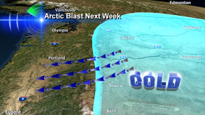
I made this main image for our 11pm newscast in KOIN6 News — and it shows what I’m expecting by Wednesday February 5, 2014. Deep cold air sliding down into eastern Washington & Oregon, then spilling right over the top of the Cascades in addition to racing through the Columbia River Gorge. That’s wind over the top of the mountains. And wind through the gap in the mountains. Translation: Brrrrrrrrrr.
This kind of set up means a variety of things are possible and our entire KOIN 6 Weather Team will be tracking them.
- Wind-chill will be in the teens for Portland and many parts of the I-5 Corridor and possibly west to the coast
- Wind-chill will be in the single digits near and in the Gorge
- Wind-chill may be below zero over the mountain passes
- If enough cold air spills over the Cascades all at once, some areas will see very gusty winds that could create scattered power outages
- This is very dry air so get ready for more dry skin, chapped lips and chances to get shocked when you touch things
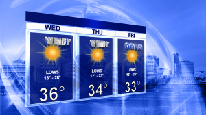
If all this excitement isn’t enough, how about these temperatures for the end of the week? The big numbers are the daytime highs I expect.
 Will we get snow on the ‘back side’ of this cold snap? That’s not clear just yet. Stay tuned weather fans…stay tuned.


Bruce- after one of the most boring Januarys I’ve seen, I’m ready for some exciting weather this month. Could this be something like the blast of February 1989?