Saturday Mid-day Update: I like the way everything looks! Gusty south winds in some parts of the valley are replaced by a northwest breeze later–a sign of cooling. That’s already happened along the coast. I can see the cold air on approach on the satellite–and by this evening we should see those hit and miss snow showers start up! The rest of the forecast below is still legit.
Remember December 2008?
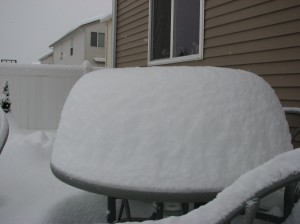
Me, too. It’s fun to look back at pictures like this one that shows 18″ of snow on a back patio table in Milwaukie!
Well, we may be adding new snow pics to your photo album this weekend–but it will NOT look anything like this in the Willamette Valley!
Willamette Valley Snow Chances This Weekend & Into Monday
If you ever watch the 11 o’clock news on KOIN Local 6 — you might think my last job of the night is a ‘wave’ goodbye ad the end of the newscast. But while David Letterman is doing his monologue I’m passing on my weather thoughts to the newsroom so we know what to plan for. Here’s the note I sent out last night and my thoughts still hold.
Saturday: Light rain by mid-day. Behind that fairly weak system…cold air floods our skies. Snow levels drop to near sea level
Saturday night into Sunday and through early Monday: Snow levels drop to near sea level and more or less stay there. That’s quite awhile with low snow levels. I think many of us get to see the snow fly this weekend! But I also believe that for most of us, this is not going to be a huge deal.
The big question: how much moisture do we get? And does the snow stick? This is a set up where we’ll see two things: sun breaks (and some of them will last a long time!) and scattered snow showers that cruise off the Coast Range and across the I-5 Corridor.
How many of these snow showers make it inland, how strong they are and do we get organized bands of showers that tend to last awhile and really dump the snow?—these are the factors that determine how much snow we get to work with. This far out, I’m thinking quite a few showers are blocked by the coast range. So that leaves us with most of our roads in good shape over the weekend but still the chance for a dusting on the valley floor in places hit by the heavier/longer lasting showers.
Get up in elevation just a few hundred feet and accumulation is more likely because the air tends to be a couple of degrees colder and that can make a big difference, believe it or not. So, we could find some slick roads over the West Hills or their equivalent type hills (outside Salem, Vancouver, Mt. Scott, etc.) at any point during this stretch of weather. But we’ve gotta get the moisture in here to make that happen.
As a bonus, if we get heavy showers during the overnight hours when temps are near freezing…that ups the chances it will stick for a bit before sunbreaks start to melt it.
Weather action continues next week…and there’s going to be quite a bit of it. So stay tuned weather fans, stay tuned! (I was ‘teasing ahead to potential for heavy rain and gusty winds…but that is SO next week. We’ll deal with it later!)
Now–here’s a little Q & A I whipped up:
Question: Will We See Snow This Weekend?
Answer: I think it’s pretty likely that most of us see snowflakes on Sunday & Monday. Possibly Saturday evening as well. But I can’t say everyone will. On Sunday, any showers should be dropping wet snow since the air above is so cold.
Question: Will We Have A Snow Storm This Weekend That Shuts Down The City?
Answer: No. This is more a snow shower and sun break situation–and we may see more sun than showers in the Willamette Valley on Sunday & Monday when the air is at it’s coldest. We could easily get a quick dusting anywhere though–even down to sea level–if heavier or longer lasting showers develop. This is possible but not certain.
Question: Will We See Accumulating Snow This Weekend?
Answer: Any Valley floor snow or coastal town accumulation will likely be light, spotty and temporary. Most or all of the weekend we’ll stay above freezing. But, there might sticking snow somewhere in hilly parts of the Willamette Valley (West Hills, etc) or anywhere above about 500′ but most places I do not expect much if anything to stick for long, if at all.
Question: Will I Find Snow Covered Roads Anywhere This Weekend?
Answer: By Saturday night, you will probably find winter driving conditions over the coast range passes and you can expect them over the Cascades,too. And anywhere over the hills it’s possible but I doubt it would last all weekend. We’ll just have to watch and see what happens with these snow showers.


Im so excited for this snow! Ive been up on SnowBnny many times this year, but snow here in Portland? YES!