Updated Wednesday Morning January 18, 10am
Well–we know which forecast tools came around to be right. Our in house RPM and the GFS were closest on timing and snow amounts. And the biggest thing is, after a high of 40 degrees, we did see sticking snow on the valley floor and more than 30,000 PGE customers without power. It was a great week of winter weather forecasting (by great, I mean pretty accurate) and we could all use more of those, ha-ha-ha! Especially the weatherman…
Original Post:
The forecast for the chance of big snow Tuesday night is like a moving target!
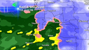
Last night at 11pm, this is what our forecast model predicted for Vancouver and points south. Rain. That prediction was so ‘twelve hours ago…’
The green and yellow is the wet stuff, the blue color is snow.
Forecast Models Agreeing Now: Portland Gets Snow Tonight & Overnight
Our in-house computer model that insisted on Portland rain late tonight has now come around to predicting snow as far south as approximately Wilsonville at the start of the incoming storm system. Last night it had the rain-snow line over Clark County. So this small move with major consequences for many of us!
Here’s the latest:
- RPM model (our in house version!) – about 2-3″ of snow from about 11pm-2am…then switching to rain after that
- GFS model – about 2-4″ of metro snow from about 11pm until about 2-3am…then switching to rain after that
- NAM model – the one that’s been insistent on metro snow all along – up to 6″ of metro snow from about 11pm until 6am…then to rain
As I like to say behind the scenes, “it’s all on paper” and we don’t know what’s going to happen for certain. A slight northward shift in the incoming storm’s track and it’ll be all rain. But as of now, odds are quite high we’re going to get some wet snow that could cause overnight power outages and lead to a slushy mess some places in the metro in the morning–where it hasn’t washed away overnight. I expect the highest accumulations in the hilly areas of town.
Right now, it looks like Salem & south will be rain only for this event.
Places Where Snow Lasts Longer, Looks To Be Even More Significant Than Portland Metro
Now, let’s go with the big snow totals:
- Kelso-Longview and LaCenter = 5″ to 8″
- Coast Range and Coastal Mountains = 7″ to 12″
- Seattle, WA = 5″ to 10″
- Columbia River Gorge 6-16″ / heaviest near Hood River
- Cascade Foothills 6-12″
- Mountain Passes & Ski Resorts 2-3 feet
Who said we weren’t going to have a winter?

Hi Bruce ; we’re enjoying partly cloudy skies with sun this afternoon. Not much snow at all here. Could get very snowy Thursday, but then again yesterday we were told the same thing for Wednesday. Friday might be the day it all turns to slush
Hi Bruce. You sure weren’t kidding about the snow! We live at NE 60th and Glisan here in Portland and the streets and our parking lot is covered. Sent a picture to Koin of our bush by the apartment.
Patty–
Thanks for your post. I was very excited to see the snow. Too bad we slept through most of the time it was here!
I saw your picture. Thanks for sending. Have a great night!