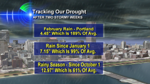
 After two incredibly stormy weeks, it’s suddenly an ‘off the charts’ wet February.
And I’ve been asked if that means Oregon’s drought is over.
If you keep reading down the graphic, you can see for yourself the answer is NO. Portland’s total rainfall since the start of the ‘water year’ or ‘rainy season’ is just 61% of average. A huge improvment for sure. But we have more catching up to do.
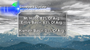
And here’s an update on Oregon snowpack as of Febraury 18, 2014.
 Mt. Hood has received about 7 feet of snow in the last 8 days. That is incredible! The snowpack test site up there, which is ‘in the neighborhood’ of Timberline Lodge, is now 83% of average for this time of year. But many other parts of Oregon have a lower percentage. That’s especially true in southern Oregon. The powerful storms that hit up north dwindled on their way south.
So, that’s the update. I’ll let you know more as we continue through the always interesting ups and downs of this winter.

Hi Bruce: Similar statistics to report here compared to yours: I’ve measured 134% of my normal February precipitation up to this point, about 101% from January 1st, but only 65% from October 1st. so, as you state, the “drought” is still going on. I don’t have lot of figures handy for the snow pack. All I know is that Mount Seymour (one of our local ski hills) reported 63 inches of new snow in the past week. In conclusion, things are indeed looking a lot better, but we’ve still got a way to go.