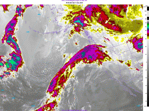
So it’s December and both Santa Clause and the ‘Pineapple Express’ are comin’ to town. Is there any chance Santa rode in on the Pineapple Express to reach the northwest? The odds are low unless he was coming in from Hawaii.

Hawaii is toward the bottom left. Oregon and Washington are on the right about three quarters of the way up. It's the Pineapple express in an image from early Saturday morning December 11, 2010.
Wait a minute, he did look a little tan when I saw him at the mall. Seriously though, the ‘Pineapple Express’ is bringing us not-so-great gifts of heavy rain and flooding.
The ‘Pineapple Express’ has a big impact on northwest weather. If you’ve been here long, you know. The pattern in the atmosphere gets its nick name because tropical moisture from near Hawaii (where the pineapples grow) gets pumped our way. Like there’s suddenly a Honolulu-Hillsboro non-stop. And this flight is only serving water! The Jet Stream transports that tropical and sub-tropical moisture and you can usually tell just where it is by looking at the satellite picture. The one here from this morning looks beautiful and ominous at the same time.
Four Reasons Pineapple Express Can Mean Heavy Rain and Flooding in Oregon and Washington
I often get asked why it’s usually the warm, wet storms — the ‘Pineapple Expresses’ of the world — that cause the biggest flooding troubles for Oregon and Washington. Well, here are for reasons that’s the case.Â
- Warm air can hold much more moisture than cold air. So a powerful storm arriving from a warm region of the globe, like Hawaii, can carry a lot more rain than our typical NW storms.
- It takes a powerful Jet Stream to move so much moisture from Hawaii to the northwest. Once the pattern is in place, it usually lasts awhile — say 1 to 3 days. Typically the focus of the rain moves south to north along the west coast and then it often drops north to south on a sort of return trip.  That’s what’s happening this weekend. It’s like a fire-hose lifting up and down over Oregon and Washington. Mountain terrain magnifies this fire-hose effect.
- Often these patterns hit when our northwest soil is already saturated. That means instant runoff into streams and rivers that handle rain well but can flood because of an extended deluge.
- With warm air comes rising snow levels. So now we’re not just pouring rain into the rivers, we’re melting snow into them, too. That’s trouble. Today, the snow level is starting around 3,500′ in the morning. By tonight, it’ll be up around 9,000′ and holding thanks to warm winds from the south.
So, with things like those at work, it’s easy to see how we get into trouble. If you were here for the floods of 1996 you experienced the Pineapple Express at its most powerul. It hit after snow and ice was all over the lowest elevations of western Oregon and western Washington. We don’t have that this time around, thank goodness. But bouts of flooding in the Northwest are more common when it’s a La Nina winter. You can see how that works on my La Nina Winter Forecast  post.By the way, check the Northwest River Forecast Center to track  rivers and streams near you. Things are color coded so you know which places are approaching flood stage or safely within their banks! You can also view the 48 hour forecast for river levels. Please let me know if you see any trouble during this ‘Pineapple Express’ weekend in the northwest!

Leave a Reply