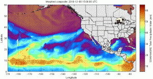
We escaped Saturday with only minor flood issues in the northwest. But we did tie a record in Portland, with 1.30″ of rain, matching the wettest December 11th back in 1969.Â
You can see why in this movie: it shows warm, humid air (the most humid in orange and yellow) breaking off from the tropics, crossing Hawaii and then lifting like a finger (the fire-hose as I like to call it) to Oregon & Washington. Give the movie a second to load but then it’s amazing. I’ve already watched it about 27 times! Saturday could’ve been worse because the fire-hose of the ‘Pineapple Express’ shifted north and out of our area about three hours earlier than forecast. That’s a big difference to rivers and streams.
More Heavy Rain Sunday, Another Chance at Northwest Flooding
Sunday starts with drizzly, drippy weather and most of us are balmy and near 60 degrees thanks to a breeze from the south. But there are a couple of things to watch before we sound the all clear on flooding this time around:Â Â
- Sunday around noon-ish, we’ll see another round of moderate to heavy rain take over Northwest Oregon and extreme Southwest Washington. Metro area rain appears to be around an inch with another 2″ – 3″ for the Coast Range and Cascades. The latest forecast tools slide the heaviest rain south and east of us during the early to mid-evening hours. At first glance, it appears this will limit the chances for widespread problems.
- Something to watch is potential development along the fire-hose of the ‘Pineapple Express’ on Sunday. If this happens, it typically slows down the system’s movement. This would mean heavier rain longer and extra problems. This may be the deciding factor in how things really go today and tonight.
- There is another wet system coming in overnight Monday into Tuesday morning. As of now it looks like we could pick up another half inch to inch of rain with that system. It’s probably moving too quickly to cause too much trouble and it will bring in cooler air to stop the snow melt in the mountains. But this system is worth mentioning.
Behind that Tuesday morning system, the snow level could drop as low as 1,500′ for a bit. And there’s a lot of cold air to our north in both Alaska & Canada right now. Some of the forecast tools we use are trying to bring that into the Northwest to finish the week – although mainly east of the Cascades for now. We’ll see how that plays out. Ahhh, a La Nina winter. Are we having fun yet?

Leave a Reply