 For most of us, the answer to the headline appears to be…not for long!
But lots of us get to at least see snow flakes this week like we did this morning.
That’s exciting, isn’t it? Or is it just a cruel tease?Â
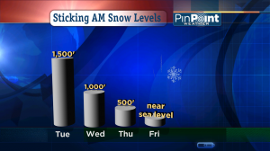
This chart shows where I expect the sticking snow level to be each morning this week in the Portland / Vancouver metro area. Although I was about 500′ too high Wednesday morning. Interesting. The heart of the cold air moves over us Wednesday to Friday mornings which is why the sticking snow level edges lower each day.
My Latest Thoughts On Snow Possibilities
- If a steady, fairly heavy line of showers passes over your house the next couple of days it could easily drop  a quick shot of snow on you. Heavy showers temporarily lower the snow level beyond what we’d otherwise expect so flakes reach the valley floor at times. That happened Wednesday morning.
- Thursday & Friday mornings are both cold enough for mainly snow showers and even a dusting on valley floor lawns with light accumulation in hilly areas. But moisture will likely be decreasing. So we’ll see. Our in house forecast simulation shows solid snow showers both mornings but it also tends to over-do-it in situations like this.
- The sun’s getting stronger this time of year, so, I believe we warm into the 40s each afternoon through the weekend, at least. So anything that turns your grass white won’t stick around long.
- Up above 1,000′ or so, if you’re hit by showers the next couple of days they should be all snow. This is where the real action will be. Watch for snowy/slushy drives in the Coast Range over Highways 6 & 26.
The Sussman kids still want enough snow to build a snowman in the yard this year. My fingers are crossed. If it doesn’t happen, hopefully they won’t blame the weatherman!
Â

Leave a Reply