 It seems like the Portland and Vancouver area is headed for the ‘weather tri-fecta’ this week:
Cold. Wind. Snow.
And as usual, the last part of the ‘tri-fecta’ is already playing hard to get. Story of my life, I tell you. Story of my forecasting life!
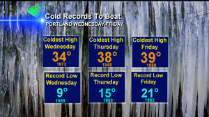
I mean, the cold is good to go. I think we’ll break many of the records you see here.
 These are the numbers to beat on February 5, 6 and 7. Looks to me like we’ll beat several of them.
And the east wind appears it will be right on schedule. Picking up Tuesday, howling on Wednesday and continuing in some fashion into the weekend.
But then there’s the snow forecast. And although I’ve cautioned everyone a ‘possible’ weekend snow or ice event is still quite a ways off it continues to be the million dollar question we all want answered right now. Snow, or no? Right?
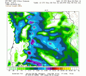
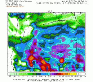
Well, we may be waiting awhile for the answer. Just consider two different scenarios that came out 12 hours apart from the WRF-GFS forecast model. Both of these maps show ‘alleged’ 72 hour snowfall ending at 4am Sunday February 9, 2014.
 Use the key, and you’ll see this one gives the Portland-Vancouver metro area between 2-7″ of snow. Yikes. But at least much fo the Willamette Valley is spared–see that ‘donut hole’ where there’s not much snow? Looks like the Central & Southern Willamette Valley see little if any snow.
 Now, 12 hours later….whoops! Now it’s the Southern Willamette Valley and south that gets the most significant valley snow. The Portland-Vancouver metro area seems to get nothing to a trace of snow.
See what I mean? It’s going to be awhile before we know how the weekend will go. Especially because snow is just one of the possibilities this weekend. Freezing rain is another thing we could be looking at here thanks to east wind coming out of the Gorge.
More updates to come…
Leave a Reply