 Ready to go in reverse?
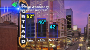
That’s what our temperatures will do Wednesday.
50s at 1am. 46 degrees around breakfast. 42 at lunch time. And dropping to 39 degrees for the evening commute.
Yep, it’s a sign of colder air racing into our skies. And it’ll feel extra cold because Portland’s high temperature of 55 degrees on Tuesday January 8, 2013, nearly tied our record high for the date which was only 57.
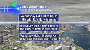
Portland Snow Outlook: Door Opens Wednesday
 This graphic I used on KOIN Local 6 News Tuesday night at 11 hits the highlights, for sure. One other thing to add to the main part of the day Wednesday is that we may have a few heavy showers roll through. These tend to change over to snow, down to the valley floor, if they last more than a few minutes. Still, I don’t see anything sticking during the day Wednesday.
By late Wednesday night, any showers around are increasingly snow instead of rain. And Thursday morning I think most anything falling will be snow–but for the Portland-Vancouver area our forecast tools are trying to limit it to flurries. For the last couple days, it’s been showing the better group of snow showers Thursday morning to be over the Central & Southern Willamette Valley. We’ll see.
Accumulation? As of right now, it’s hard to imagine more than a dusting. And most of us won’t even get that. But a few ‘bonus bands’ of snow showers could quickly change things. The time to watch will really be Thursday morning.
It looks to me like Oregon & Southwest Washington start an extended dry stretch by Thursday night and we could be mainly dry through much of next week. And most of the time, it looks chilly, too.
So, I hope you enjoyed the 50s the last couple of days. Because they…are…outta here!

Bruce; I’m ready for any “dry stretch” here , even if it’s only for a couple of days! The rain ended in my area about 10pm last night and good riddance to it! The last 6 days I’ve seen an ever increasing daily amount: From Jan.3-8 we went: 0.11, 0.27,0.37,0.51,0.89,1.34 inches respectively.
Bring on the cold air and sunshine!
Hey Bruce, what are you thinking about this weekend? I see a lot of the models have brought the Saturday/Sunday storm back to moving right over the area. 06z and 12z runs of the GFS are in support. 12z GFS is perfect actually and has some places getting 6″ even with a widespread 2-4″ event… FLIP flop FLIP flop, that’s all they’ve been doing. The 12z NAM seems to be in support to with snow over Seattle at 84 hours. Any chance you’re going to tweak the weekend forecast? Only 3 days away, i’d say its something to keep an eye out for. Give it another 24 hours consistently showing up on all the model runs and were talking serious business! WIDESPREAD SNOW. PANIC. BREAD MILK (COOKIES).
Jordan–I think it’s cold enough for snow in the valley–and possibly even cold enough to see some white beaches along the coast. But our forecast tools cannot decide on the track or strength or speed of this system. Some say it will be mostly or totally dry.
So, I’m currently hunting for my magic 8ball and will get back to you after I ask it what’s really going to happen!
Thanks for the question.
Thanks for the reply, Bruce. Let’s hope we get a good storm out of this! 00z GFS sure did something completely different — here we go again with flipping and flopping. haha.
Looking at the track of the last storm and the Low to our east not really moving far away, I think that we could see a significant SNOW EVENT with this next system Saturday. Interesting how moisture was convirging over Kelso and developing as it came towards Portland the other night ha. I love a good snow storm! I really like your enthusiasm with weather! Keep it up! Boyd….
Boyd–these systems like to play tricks on us. But in this case, it appears it’ll just be passing by. Could have gone either way, though, for sure. Thanks for posting and have a great weekend!