 There are two things to watch for this weekend in the Portland metro area and other parts of the I-5 Corridor.
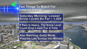
#1 – I expect the lowest snow levels this season on Saturday morning. In the neighborhood of 1,200′. The tip top of the West Hills is around 1,100′ and the Sylvan summit on Highway 26 is about 750′. But as I mention in the graphic here, if the rain is heavy enough over the metro area it can help cool the air and bring the snow level down into hilly parts of town for awhile on Saturday morning. Once the moisture decreases in intensity, the snow level should jump to 1,500′ or a bit more. At the lowest elevations, it should mainly or totally be rain.
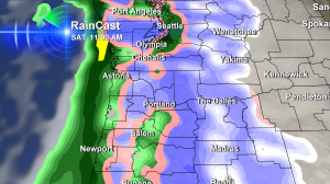
 Here’s our rain & snowcast for Saturday morning at 11am. It’s probably over-playing low elevation snow in Clark County–but the idea is good, it’s ALMOST cold enough for snow at the lowest elevations. And hilly areas may indeed get a taste of winter! (Note: it’s possible even colder air comes in at some point during the Tuesday-Thursday timeframe. That’s still a long way out there though…but it’s worth watching.)
#2 – Better keep an eye on the wind. Storm track will make or break this one, but gusty winds are possible Sunday night into Monday for the I-5 Corridor and pretty much everywhere else. In general, it will be breezy at times this weekend. But Sunday night is when I’ll really start watching a storm center that’s likely going to cut inland over Puget Sound or B.C. Where it goes will determine what we get!
The Cascades and Coast Range Mountains This Weekend
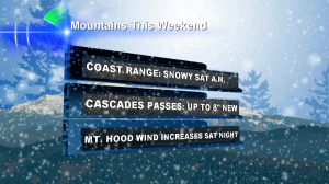
 It’s going to be a winter wonderland on Mt. Hood this weekend! I’m thinking a snow advisory is likely on Saturday and snow should really pile up. Even the Coast Range will be a winter driving experience on Saturday morning–especially the Highway 6 & 26 summits. I believe things thaw out on Coast Range roads once the heaviest rain moves through.
That’s it for now. Have a great weekend!

Leave a Reply