It was last Thursday morning when our forecast simulations lit up with snow plowing into Washington & Oregon. That night on the five o’clock news is when I started talking about the potential for something big around here. Since then, the forecasting tools we use have taken us on more twists and turns than a John Grisham novel.
A day and a half ago, it looked like we could get 14″ of snow in Portland from Wednesday-Friday. As of last night that number was more like 3-6″ with snow starting Tuesday afternoon and a much faster warm-up for all areas except near – and especially in – the Gorge. Twists. Turns. It’s the stuff our northwest winter storm forecasts are made of!
Winter Storm Forecast: Where We Stand As Of Sunday Afternoon
- we get increasingly cold, dry & breezy as the work week starts. Lows in the 20s, highs slightly above freezing most places
- snow in the metro area starts by the Tuesday evening commute, perhaps a little earlier
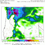
- accumulation by 11pm Tuesday: our KOIN forecast model keeps us at 1″ to 2″ in the metro with little or no accumulation for Salem & points south. But another forecast model gives us 2″ to 4″ of snow on the ground in the Portland metro and maybe a quick inch or so for the Salem area (see the colors on this chart). So we still need some fine tuning–there’s wiggle room in both directions!

Â
Three important things about this forecast
- The trend the forecast models developed over the weekend was to shift the main storm’s center of low pressure increasingly north of us. The more north it goes the faster the valley warms up, the shorter the snowfall and the less snow we accumulate. You get the picture.
- But the freezing cold east wind remains a wild card here. And it’s such a small scale thing that our forecasting tools have trouble understanding exactly how it will impact us. Often it keeps parts of the metro area below freezing while the rest of the I-5 corridor is well into the 40s. This could happen again, perhaps giving some of us  freezing rain overnight Tuesday night into Wednesday morning. On paper, most of the metro area warms into the 40s sometime on Wednesday. We’ll see.
- This event has “I-84 is closed” written all over it. Those of you in the Gorge could see 6-12″ of snow by Wednesday morning. Then, we could see pockets of freezing rain. Worst of all, our KOIN computer model gives you a serious ice storm from late Wednesday afternoon into Thursday morning. Right now, it looks like that’s from one end of the Gorge to the other.
I’ll post another update with any significant forecast changes by around 9p.m tonight. We can probably expect more twists and turns. John Grisham would be proud of the way the Northwest does winter!

Sounds too much like two years ago when we got hammered and my car got caught in a snow drift in a Safeway parking lot and was there for a week until they plowed the lot. Do not look forward to this
Luckily the air in place will be a little warmer to start and we should get a nice south wind to warm us fairly quickly. But you east county folks usually have to wait a little longer. Hopefully not too long, right?
I wish we would have a serious storm. I am from Racine, Wisconsin. And that city is right on Lake Michigan. I know what walking to school with 28′ snow drifts with a temp of -25 Degrees. I walk sometimes in the cool air just missing the snow.
Chrissy–I hope you were here in 2008. That may be about as close as we ever come to your Lake Michigan snow. Someday, I’d like to be there for one of those big snows!
I was looking forward to a big snow event here in Hillsboro. Not having been in Hillsboro that long, it seems as though it does get a bit colder here than in the Portland area. Is that true and does that change the outlook of this snow? Come on snow! I bought all my kids snow clothes this year due to the La Nina forcast and it has been a dud winter so far!
Sometimes being out west toward the coast range can get the Hillsboro area more snow. But in this situation it probably won’t help. La Nina’s worked out great because it’s supposed to mean more snow in the mountains. But it’s no guarantee for the low elevations. I’m hoping for snow just so you get some use out of the snow clothes before they grow out of them!
What do the records show us as the possibility of still getting a good snow event by the end of January or February? I figured if we did not get snow by December that it was not going to happen this year.