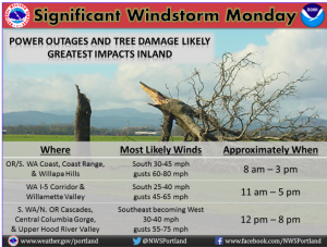
Here is a graphic that the National Weather Service in Portland put together with a simple breakdown of what we have potential to see as we roll through our Monday.
Although highest gusts will be along the coast (pretty typical) the strength of inland gusts for Salem, Portland, Vancouver and the I-5 Corridor will likely have the biggest impact. Gusts will be 45-65mph — and if we come in at the higher end, we can expect some significant tree fall damage and power outages.Â
In my two decades of forecasting weather in Portland (man, I’m getting old!) wind forecasts have always proven to be the trickiest. Even harder than the much joked about snow forecasts over the years! This is because tiny details make a huge difference in what actually takes place.
With a rare High Wind Warning issued for the I-5 Corridor (and the Coast and Cascades clear into Central and Eastern Oregon), think carefully about afternoon travel plans and check out the National Weather Service page for updates for Western Oregon  and Central and Eastern Oregon as we go through Monday.Â
Whatever happens, winds drop off significantly Monday evening.


MERRY CHRISTMAS . MISS YOU ON THE WEATHER .
Thank you, Bonnie! Merry Christmas to you as well.