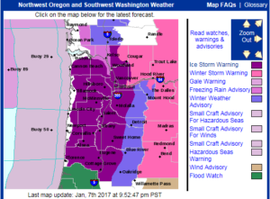
 It happened while I was in the KATU Newsroom Saturday night.
My phone buzzed (it was my KATU News Mobile App Android –  Apple) and it read: “National Weather Service Issues Ice Storm Warning for the Portland Area, through 10pm Sunday night.”
Ice Storm Warnings are rare in Portland because we typically transition pretty quickly from snow to freezing rain to regular rain. But not this time, for many.
Maybe you already knew this was coming because you read my weekend forecast from Friday. If so, let this be confirmation that you’ll want to stay home if you can on Sunday, just so you don’t have to worry about the slick factor.
Update Sunday Ice Timeline (as of 2pm Sunday):
- Light ice possible from passing showers early Sunday morning (note: this happened)
- Significant Ice Build Up: 9am-ish to 3pm-ish (actually started closer to 8am / many places are thawing now, near Gorge and in isolated pockets around the valley, ice accumulation continues)Â
- Into tonight: rain, heavy at times for most; freezing rain continues in/near the Gorge, except further into Gorge where it’s still snowing!
- Monday AM: I think the majority of us see plain old rain showers, however, near the Gorge, many areas will be very slick.
Lastly, Tuesday night into Wednesday AM is worth watching for possible snow to the valley floor–or even for freezing rain. Just a heads up to keep your eye on the weather this week as the ‘hits’ keep on coming.
Have a safe Sunday and here’s to keeping the lights and heat on Sunday into Monday!

keep up the great work. my Wife and I reading your forecast and comments. Weather forecasting has come a long ways since I was a kid, but still can be very challenging even with the different instruments that are available.
Thank you for the nice comments – it certainly has been an exciting fall and winter when it comes to the weather!