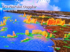
 Probably the best thing about having to work a ‘bonus’ Saturday night was the chance to use one of my favorite weather tools: our exclusive 3-D PinPoint Doppler.
I love it because of how it looks (cool, right?) and because of what it does.
This single image is from 10:13pm on Saturday night January 14, 2011. It shows exactly and soooo clearly what’s headed into Oregon & Washington as we roll into Sunday.
I see small single cell showers that don’t jump off the screen very much. They’ll probably make it to the Coast Range and die off long before reaching the Willamette Valley or Portland.
And I also see groups or bands of showers–you can tell these are more intense because they really pop in 3-D right off the screen. These are the areas of (mainly) snow that can survive and get over the Coast Range more often.
Finally, notice the big breaks in-between these shower areas? That tells me there’s clearing in-between each round of action. That’s why I’m sticking with my Sunday forecast of sunshine–and occasional snow showers cruising through.
I hope you see snow today. And thanks to those who have posted snow reports over on my Facebook weather page, I really appreciate it! And I’m glad the weekend forecast seems to be on track.

Leave a Reply