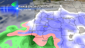
 Notice the time on this graphic?
It’s 5pm on Thursday February 6, 2014. And if the snow is really going like this…you know the evening commute is going to be a mess!
Here’s the note I sent out to our KOIN News staff last night:
**Flurries possible anytime today.
**Steadier, accumulating snow becomes increasingly likely as Thursday goes on. It could show up late morning, but early afternoon seems more likely in the PDX metro area.
**Morning commute is likely just cold. Wind Chill of -5 degrees to +10 degrees. Evening commute may be in ‘Portland panic mode’ because it’s snowing and snow is
likely accumulating at that point.
It appears most of the metro area will get between 1-4†of accumulation by late Thursday evening. The actual number will be determined by how long the ‘snow zone’ is over us. Gorge is looking at 3-6″ of snow. Coast a dusting to 2″ or so–with some spots just getting some rain. Salem & Eugene and points between my see 1-6″ of snow.
Three other things to think about:
#1 – Elevation will not matter in determining who gets snow or not…because temps will be in the 20s.
#2 – Because it’s so cold, this will be a lighter and less slippery to drive on snow than Portland typically has
#3 – Blowing snow may actually reduce visibility around parts of the Portland-Vancouver metro area thanks to the east wind
Thursday Warnings:
**Winter Storm – Entire I-5 Corridor, Vancouver to Eugene
**Blizzard – Columbia Gorge for possible blizzard conditions in the afternoon & evening
Adivsories:
**Wind Advisory for metro area
**Wind Advisory for metro area
**Winter Weather Advisory for Oregon Coast – snow accumulation is possible
Facts:
We’ve already had record cold – Wednesday’s high of 29 degrees was Portland’s coldest Feb 5th…ever!
That’s all for now. Stay warm!

Leave a Reply