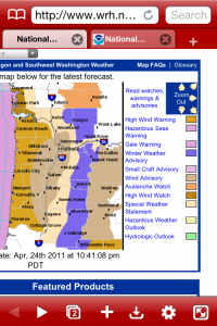
Updated: the storm center at the surface – moved inland south of the Portland area. So that will mean less wind and most of the advisories and warnings are now cancelled. However, it’s still going to be breezy at times with some nice afternoon downpours!
During the winter months, it’s pretty common to see the map on the Portland National Weather Service Page painted in colors.
Each color represents some sort of advisory or warning.
But this is a snapshot of that screen looking forward to all the wild weather expected on Monday April 25, 2011.
Unusual for this late in the year.
We’ve already survived a very wet Monday commute. Next is significant snow for Cascade Mountain Passes. Then for most of us, the chance for small hail later in the day along with a thunderstorm or two. But I really want to talk about the wind.
Bad Timing For Gusty Wind To Hit The Willamette Valley & Southwest Washington
- The Portland-Vancouver metro, will possibly see wind gusts from the south / southwest of 40-50mph at times on Monday. Gusty winds should develop by mid-morning. This is really bad timing because many of our trees have at least partial leaves grown out. Each one of those small leaves acts like a tiny sail to catch wind. That, combined with our muddy soil right now, increases our chances for downed trees and power outages as we go through the day. A Wind Advisory lasts until 5pm Monday.
- The Salem area and south to Corvallis and Eugene could possibly see even stronger south/southwest gusts of 50-6omph, so a High Wind Warning lasts until 2pm Monday. Gusty winds are already underway, as of 7am.
- The more north you are in SW Washington, the better your chances for avoiding this whole thing. The strongest winds are south of where the storm center comes onshore–that puts the ‘wind bullseye’ over extreme SW Washington and Oregon.
- Coast: South winds should peak in the 55-70mph range. A High Wind Warning is in effect from 5am to 5pm.
- Central Oregon, including Bend & Sunriver: Wind Advisories are in place from 11am – 11pm for south wind gusts of 35-45mph.
So, I guess La Nina’s not done with us yet, even though La Nina conditions in the ocean are weakening. One of our coldest and wettest Aprils on record just keeps that trend on track!
Have a great Monday – and if you see anything crazy, please let me know over on my Facebook Weather Page. Thanks again for reading…and for all of your help!


Leave a Reply