Time is ticking toward spring.
 As if the Crocus & Daffodil heads popping up aren’t sign enough, I even have a ‘spring countdown clock’ half way down the right side of this page.
But neither of those things are why I wrote this post. Instead, it’s the questions people are asking me almost everywhere I go right now. “Is winter over? No real snow for the valley floor this year, is that right?” Well, here are four things I know for sure:
- Statistically, January & February are the most likely times for a decent I-5 corridor snow storm.
- Whoops, January is ending unusually dry & mild
- This same thing happened in the La Nina winter of 1988-89, too, then February turned very, very cold
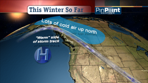
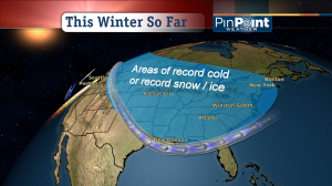
- So far, the major trend for winter cold this year takes it everywhere but the west (see my graphics)


This whole bit of waiting for the equinox when it comes to spring is really annoying. If we’re gonna do it for spring we should do it for all the other seasons too. Personally, I like to think of winter as running from Nov. 20 to Feb. 20 since that’s the coldest average three-month period. Summer is from Jun. 20 to Sep. 20 (basically in line with official definition), giving us four months of spring and two months of fall.
But the last few days have sure felt more like late February or early March than like January. In the eastern Columbia Gorge the hills are already flushing green in areas without too much dead grass/weeds from last year to obscure the green. I realize that you usually get a hint of green in late fall and early winter, but the process has definitely accelerated since the last cold spell ended a week and a half ago. What’s really unusual is that it’s stayed mostly warm since last week’s Pineapple Express ended, rather than reforming any kind of cool pool over the Columbia Basin. The ridge over us isn’t quite solid and well-centered enough yet to induce a fogversion in the lowlands.
We MIGHT get a February cold snap this year if a ridge like the one overhead right now retrogrades enough. More likely though, I think, is a gradual disintegration of the warm bubble over the West Coast as we move into early February. We might then transition into a chilly/damp period more characteristic of La Ni~na years, perhaps with a couple ‘subarctic’ storms from the Gulf of Alaska bringing snow levels down to 500-1000′ or briefly to zero in some spots. Or the ridgy pattern could return at some point later in February when the sun is getting strong enough to potentially cause some serious spring-like warmth in the lowlands (highs of 58-65 if I had to put down a number). If we had a February cold snap, even a moderate one with hilltop snow, followed by 60-degree sunshine it would feel especially dramatic.
Bruce
I remember the GREAT February 14th snow storm in the early 90’s. Even though the long range trend is for colder and wetter, I’m having my doubts. But, the only certain forecast is for yesterday, so I’ll keep my fingers crossed.
Paul–I love your line that, “The only certain forecast is for yesterday.” Too funny and also true!