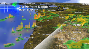
 This is snapshot from our 3-D PinPoint Doppler that I used on the 11 o’clock news Monday night on Koin Local 6.
It shows the nature of the snow showers we’re working with Tuesday. They’re scattered into small groups, narrow lines or individual shower cells. You can see all of these if you look along the Oregon Coast in this image.
Scattered showers allow some areas to get a dusting or quick inch or two of snow but they rarely lead to an all out snowmaggedon event here in the Willamette Valley or Portland-Vancouver metro area. And this is what we face on Tuesday. More scattered showers that will wind down as the day goes on.
Watching Early Wednesday For Portland & Willamette Valley Snow
But here’s one to watch. Just after 1am tomorrow (so just after Wednesday gets started) our forecast simulations show a very moist system moving into the cold air that’s in place over us now.
 As you can see–it switches everyone except the Oregon Coast over to snow. Widespread, and this time, all the way down to the valley floor and lowest elevations around Portland. The good news (if you don’t like driving in snow!) is that ‘allegedly’ breezy and mild southwest winds overcome the snow sometime by about 4am and after that it’s just a wet and breezy day and the snow if gone almost as quickly as it fell.
Of course, this timing may be revised. If there’s one thing I know about a ‘warm up’ that’s waiting on wind, it’s this: sometimes the wind is early…and other times it’s late. And the snow hangs on.
I’ll have the latest twists and turns on my evening forecasts tonight. Talk to you then!

Hi Bruce: Currently we’re having heavy snow here, but the temperature has stayed above freezing all morning. Consequently, it’s very wet snow, and while I’ve been measuring it (about 2.75 inches at 9:30) it’s compressing and melting. Yuk!