“27…42…set…huuut…snow!”
 That might be the call that starts it all on Super Bowl Sunday 2017 in Portland, Vancouver and other parts of the I-5 Corridor.
That’s right, just what we’ve all been asking for: more winter weather that could disrupt our plans (and Monday school?) again.
I was doing the evening weather duty at KATU the last couple of nights and I accidentally tripped the ‘it might snow again’ panic alarm in the newsroom when I spilled the beans on this one.
I looked at 4 different forecast models Friday afternoon and all of them were predicting snow to the valley floor on Sunday around the metro area and points north–and possibly south and west as well.
One of our producers even suggested that if you have multiple Super Bowl party offers–then choose the one with the most guest bedroom space–just to be safe! That’s good stuff, wish I would have thought of it myself.
Snow Outlook for Super Bowl Sunday
First of all, this forecast is not a done deal just yet. Especially because if the storm lifts more to the north than expected, we could dodge the snow altogether. But as of now, here’s how it looks.
- Rain and temperatures in the 40s very early Sunday, then temperatures falling and things change to snow many/most places in the metro area and points north. I’m not sure yet about Salem and points south. We’ll see.
- Timing: the forecast tools have not agreed on this just yet. As of early Saturday, at least two forecast models claim the switch happens mid-morning Sunday as rainfall rates become particularly intense and that cools the air enough for snow. Although at first it may not accumulate too much. These models are calling for a surge of moisture around 10am-ish to accomplish this. But this far out, the timing is tough to nail. And at least one model makes the switch late in the day–with most of the snow falling Sunday night.
- Snow Totals: how much snow could we potentially get in Portland? If you want to bold the word potentially, I’ll go along with that question, and say here are a few examples of what’s possible:
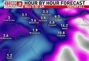
 This is KATU’s exclusive Barons Model. It has the lowest snow totals of all the forecast models I’ve seen – but still impressive, with 1-9″ across the metro area, heaviest right by the Gorge.
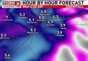
 This is the North American Model which typically I don’t pay much attention to, but here it is. It distrubutes the snow a bit more evenly across the metro area – and notice the major differnce in snow forecast for Keizer between the two. Clearly, this is not the final answer.
I won’t post the images here, but the GFS Forecast model is calling for 5-10″ across the metro area and the European forecast model (which forecasts for points around the globe, fyi) is suggesting 2-5″ across most of the metro area.
What could change and give us just a wet day of Sunday rain? Several things could. For example, if this system comes in 100 miles north of where it’s supposed to, rainfall rates would be much lighter and all we get is rain across the metro area. Those of you north of Clark County would see signifcant snow under this sceneario.
If we do get snow, it’s going to be the heavy and wet variety that often breaks branches and can cause power outages. Let’s just hope any of that waits until after the big game!

Leave a Reply