 Sometimes, one picture does it all.
This is one of those times!
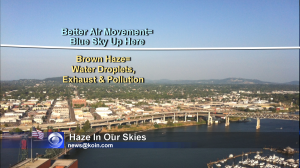
I snapped this from our KOIN Tower Cam overlooking the east side of Portland and the Willamette River.
Can you see the color difference between the top of the picture and halfway up in the sky? Mount Hood and Mount St. Helens were impossible to see because of the haze.
Ocean Air, Pollution, Leading To Haze
I first noticed the haze over the weekend when humidity came up and some ocean air moved its way into the Willamette Valley. The microscopic water droplets and perhaps even salt in the air combined with exhaust from our cars and other smoke & pollution to create a kind of brown soup. Normally we don’t notice this because our frequent storms keep things mixed up and moving on.
But in this calm pattern we’re in, the particles in this haze, just kind of hang out. Meanwhile, above the white line I’ve drawn on this picture the air is doing a better job of getting ‘mixed’ or stirred up and that’s leaving it much bluer and brighter. Pollution can’t settle in up there.
Stronger winds at the surface and lower levels of the atmosphere would help clear this out. A northwest storm system would do the trick, too. But for now, it looks like the haze will hang out a little while longer.

What a crock. This exact same white haze is in the Mission Mountains in Montana, in the corn fields of Eastern Washington and Oklahoma, in the horizon in Maui and virtually everywhere. The weather conditions and population are vastly different in all of these places yet there is one common denominator…airplanes doing criss-cross patterns in the sky, creating “clouds” from the so-called “contrails.” They are spraying nanoparticles of metals in the air to create these “clouds” and those particles are falling to the earth creating this haze.