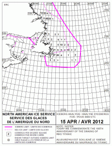
 It may not look like much, but this map (click on it to make it bigger) is one of the big lessons we learned form the sinking of Titanic 100 years ago today.
This is the map of known icebergs — of varying shapes and sizes — moving around the north Atlantic Ocean right now. This map is for April 15, 2012…exactly 100 years after Titanic sank in these waters.
Inside the solid pink line is where icebergs exist. And the number in each square represents the number of icebergs within that area of the ocean.
This is created by a division of the U.S. Coast Guard (and co-operating governments) that’s called the International Ice Patrol. Except for times during the two Word Wars, this Ice Patrol has operated ever ice season since 1913. That’s right–it started as a result of the Titanic’s collision with the iceberg.
And guess what? No ship that’s listened to the warnings and advisories from this Ice Patrol has ever collided with an iceberg. For the last 99 years!
Now that’s what I call one big lesson we learned from Titanic.

God bless the Coast Guard! They do so many things and do them well that people don’t even think about, I guess because they don’t have to! I’m so proud of my Coast Guard vet husband!
Sue@Seaside
Thanks, Sue–you’re right–we don’t think of them often enough!